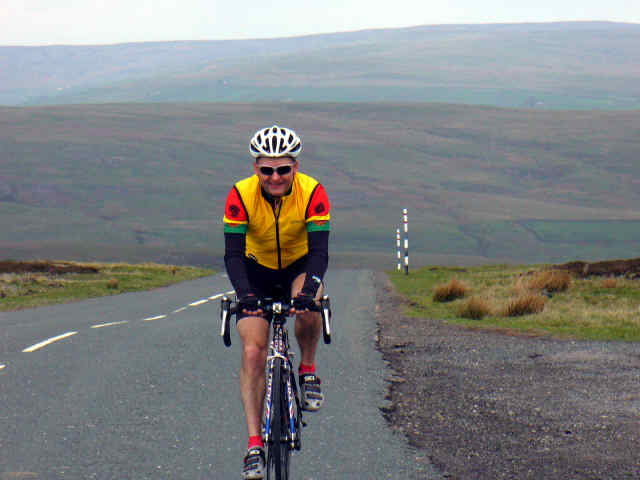
Great Climbs of the UK
Much of the fun comes when the road goes up, though some of my friends do take exception to this view. And whilst I would be the first to admit that riding a bike up hill is hard work, the real fun comes when you get to the top and it's time to come back down. Many of the climbs feature in a recommended publication, 100 Greatest Cycling Climbs by Simon Warren.
Early days yet, but what I hope to build up here is an eclectic view of my own favourite climbs of the UK. I feel sure there will be those of you who will shout vociferously that I have omitted many of your favourites. But this is MY list, and I make no apologies for it.
So, here goes...
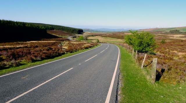
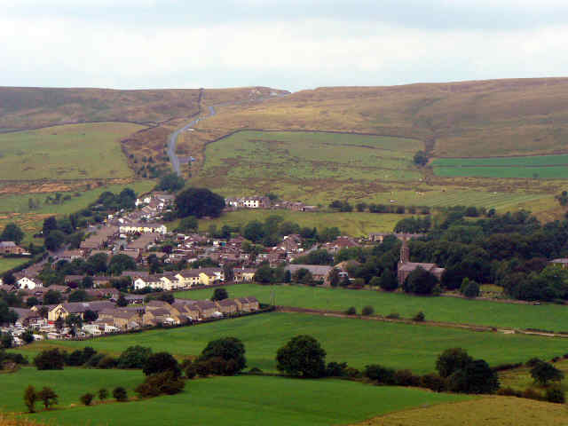
The Cat & Fiddle (1)
 This has to be one of my favourite UK climbs, especially given the number of times I head south to ride it! The road heads east out of the centre of Macclesfield, Cheshire, starting at a modest 141m and climbing to the infamous Cat & Fiddle pub at the summit, reaching 515m over an 11km climb. After the initial 3km which is fairly steep, the gradient eases. At halfway you get a first glimpse of the top, still 5.5km away, but by then the hard part is over. There is even a downhill section after about 6km. Then it is onto the big ring and power to the summit. Whilst not especially difficult, it is a lovely climb with expansive views over the Cheshire countryside. Do it!
Total ascent: 417m
Distance: 11.4km
Average gradient: 3.7%
Best time: 28' 04"
The Cat & Fiddle (2)
 The beauty of the Cat and Fiddle is that there are so many ways to climb to the summit. Perhaps the most enjoyable and scenic is up through the beautiful Goyt Valley. The single track road from the Goyt Valley Reservoir winds its way up through heather and bracken lined moorland at a gradient that is a joy to ride, until the last 1.5 km where the road does a sharp right at Derbyshire Bridge over a cattle grid and rises up at 10% before you finally see the pub on the skyline ahead. On a fine summer evening this has to be one of the most delightful climbs around. The trick is to join it up with the climb above to make it into a great evening ride.
Total ascent: 225m
Distance: 6.4km
Average gradient: 3.5%
Best time: 19' approx
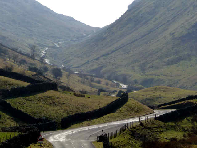
Hartside
 This seminal climb up onto the roof of the Pennines, east of Penrith is also features in local hill-climb time trials. The climb proper starts in Melmerby on the main Penrith-Alston road, at 156m, climbing steadily to the Hartside cafe high up at 580m. As with the Cat & Fiddle, this is not a hard climb, but rather is steady all the way. As you climb through the trees lower down, the views across to the Lake District fells open out. The summit does not come into view until the last 2km or so, and there is a final 180 degree hairpin before the final ramp to the summit. As with the Cat & Fiddle, it is the length which makes this climb.
Total ascent: 424m
Distance: 8km
Average gradient: 5.3%
Best time: 25' 37"
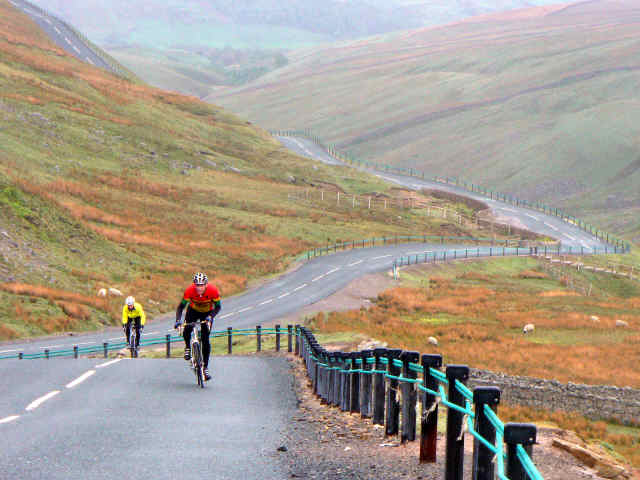
Bealach na Ba
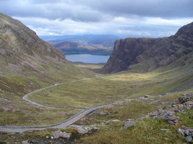 This must be one of the most amazing roads in Britain, indeed rated 11 out of 10 in the aforementioned book. It climbs from sea level to over 2000 feet in just 6 miles, and winds its way through truly superb mountain scenery on the north-west coast of Scotland. The climb starts innocently enough, with a gentle ramp for the first couple of kilometers, then gradually the gradient steepens as the scenery gets more and more in your face. The last kilometer or so before the hairpins near the summit is horrendously steep at about 20% and seems to go on forever. The hairpins provide some respite and finally you top out and collapse to draw breath. Awesome. Don't forget to take in the views back down the pass. And if you can, try the Bealach sportive to get a taste of this magnificent climb.
Total ascent: 616m
Distance: 9km
Average gradient: 6.8%
Best time: 43' 1"
Rest and Be Thankful, Argyll
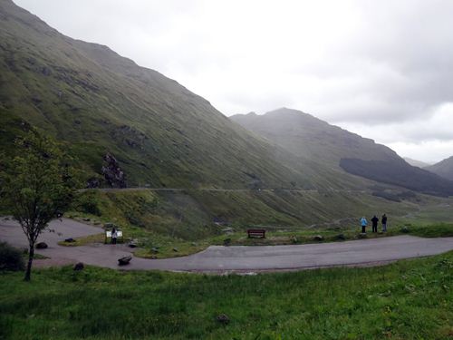 West of Loch Lomond and Loch Long, the A83 rises gradually from Arrochar up Glen Croe, a long steep-sided valley, to a saddle before dropping down to Loch Fyne. Rest and Be Thankful are the words inscribed on a stone placed here by soldiers using the old military road through the hills. In truth, Rest and Be Thankful is 3 climbs in one and can be approached from east or west on the A83, and also from the south-west via the wilder, steeper Hell's Glen.
The longer main road climb is a steady 7 kilometer drag. After running alongside Loch Long, the road swings right away from the loch and the climb starts, gentle for the first kilometer or so. Gradually the gradient kicks up to 7% and this sets the pattern for the remaining 4 kilometers, for most of which you can see the summit of the climb up ahead. Climbing into a fierce headwind, this is pretty relentless, on a warm still evening it would be heaven! Finally the road swings round to the left and the crest of the saddle is reached, rewarding you with splendid views back down the length of the climb.
The nicer approach is from Hell's Glen, the road coming up from Lochgoilhead. This follows a wild, wooded valley with heather and a tumbling burn for company as the craggy mountains close in. Easy to begin, on a good road surface, the single track road twists and turns its way steadily upwards before kicking upwards, reaching a more testing 16% before finally easing, cutting between the hills and dropping down to the Rest and Be Thankful junction on the A83. Quieter and wilder, this is the preferred climb in my humble opinion.
Total ascent (Hell's Glen): 277m
Distance: 5.2km
Average gradient: 5.3%
Best time: 18' 59"
Devil's Beeftub, Moffat
 The Devil's Beeftub is one of those climbs that you dream about. Not too steep, and so very long, unusual in British climbs. It heads north out of the little town of Moffat in the Scottish Borders, on the A701 Edinburgh road and begins climbing immediately. The gradient is almost constant for the duration of its 11 kilometers length, climbing just over 300 metres in total. Defintely one for the big ring, the climb takes you up through some woodland before opening out as the moors and valley roll away to your right. A sharp hairpin just before the halfway mark brings you out onto the open upper slopes of the climb and the landscape takes the breath away, you can see ahead toward the distant summit of the climb. Below the valley deepens until it is suddenly surrounded by a headwall, creating the famous Devil's Beeftub from which the climb gets its name. I have only ridden this climb a couple of times, and one of those was at night! The second time was the most glorious spring day with views to inspire, well worth a short day out on the bike.
Total ascent: 306m
Distance: 10.5km
Average gradient: 3.0%
Best time: 29' 57"
Horseshoe Pass, Llangollen
 Climbing north out of Llangollen on the road to Ruthin, Bwlch yr Oernant, or the Horseshoe Pass, is a dramatic climb featuring ahuge loop as it gets near the summit (hence the name). The climb proper starts at Pentrefelin, some 2 miles out of Llangollen and after a gentle section ramps up past the Britannia Inn. The climb is never truly steep but there are a couple of pitches that test the legs, and its length is enough to keep the lungs working. After the horseshoe, it eases and reveals dramatic views back down whence you've climbed. The final bend takes you to the summit of the climb with a sign for the ubiquitous photo.
Total ascent: 322m
Distance: 6.1km
Average gradient: 5.4%
Best time: 21' 10"
Road to Hell, Denbigh
 Don't be fooled by the average gradient, this climb is a veritable beast. It climbs high up on to the moors above the market town of Denbigh in North Wales, winding its way through hamlets and inexorably up to the vast expanse of Llyn Brenig, a moorland reservoir much loved by mountain bikers and walkers alike. The climb starts with a short descent from Denibigh Castle before starting in earnest with a hairpin and then it taps away at your energy. As you climb so the views to the hills open ahead, but first there is a nasty 18% section, some 800m of it, to test your metal, before a sharp descent and now the route to the summit is clear. A steady winding climb up through leafy lanes brings you on to the moors themselves and at this point bizarrely the road suddenly widens into a veritable highway before the last sweeping and punishing 12% ramp to the top of the climb. It feels every one of its twelve kilometers but is definitely a worthy ride.
Total ascent: 471m
Distance: 12.05km
Average gradient: 3.9%
Best time: 40' 22"
Stwlan Dam, Ffestiniog
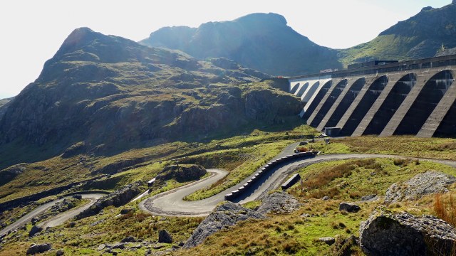 The Llyn Stwlan dam nestles high up in the Moelwyn mountains above the town of Blaenau Ffestiniog, an industrial setting with a glorious mountain backdrop. The lake is a reservoir feeding a hydroelectric power station down on the valley floor and the dam is accessed by a service road from the village of Tanygrisiau, and although short is a relentless slog up the side of the mountain. Used as much by walkers to gain access to the Moelwyn summits as it is by vehicles, the road is open to cyclists who can pass through the gate at the bottom and straight on to the 10% ramps which persist for much of the climb. There is a brief false flat about halfway up where there is some respite and you can gaze out over the power station below and the moors to the south. Then it is on to the final steep slog to the dam itself with the final pull up some 7 or 8 hairpins where the gradient is comfortably into double figures. Fortunately it doesn't last and as you come round the last hairpin you can finally see over the dam wall and over the waters of Llyn Stwlan with the crags of Moelwyn Mawr towering behind. It is an awesome place.
Total ascent: 269m
Distance: 2.75km
Average gradient: 9.7%
Best time: 26'09"
Great Dun Fell
 The north Pennines, east of Penrith in Cumbria features some big hills, notably Cross Fell (the roof of the Pennine chain) and neighbouring Great Dun Fell, more famously known for the golf ball structure on the summit. At 847m, and with tarmac going all the way to the summit, it is a worthy challenge. Some might even say brutal. The ascent is essentially a there and back ride, rising from the village of Knock, near Dufton. Approaching Knock from the Eden valley, the golf ball hill dominates the countryside around and the hill looks incredibly intimidating. The road climbs almost immediately, and steepens in sections to what must be approaching 25%. Once above the cattle grid at about third distance the land opens out and the views over the Eden valley distract the mind from the pain. But there is little respite (a short flat section at about two-thirds distance) before the final steep section through a gully and suddenly the summit is near. There is still a little sting in the tail before the legs finally can rest. And then, of course, there is the glorious descent.
Total ascent: 630m
Distance: 7.6km
Average gradient: 8.3%
Best time: 37' 46"
The Burway, Long Mynd, Shropshire
 The Long Mynd is a vast upland area rising steeply to the west of Church Stretton in Shropshire. High on the moors the heather spreads far and wide, with deep valleys cutting into the upland. Narrow steep roads thread their sinuous way up onto the Mynd, the most notable being the Burway, a steep single track road out of Church Stretton itself. It is notoriously difficult, Simon Warren gives it 9 out of 10 in his 100 Greatest Climbs, and Chris Boardman won the National Hillclimb championships here in 1989. The climb begins immediately and crosses a cattlegrid taking you out onto the open hillside, a deep valley falling away on the right. It is spectacular - and steep, very steep. There is little respite for pretty much a couple of kilometers as the road twists and winds its way up the heathery slopes before, finally, easing. The last kilometer is a delight by comparison, with views that reward the brutal effort.
Total ascent: 285m
Distance: 3.0km
Average gradient: 9.5%
Best time: 23' 39"
White Horse Bank, North York Moors
 Those of you who are used to ridng in Yorkshire will know that it is anything but flat. True it has areas of great flatness such as the Vale of York, but there are plenty of upland areas to test your legs. The North York Moors is, perhaps, the most demanding with some brutal gradients. White Horse is not the steepest, but it has its moments and there is plenty to keep you out of the saddle. The climb eases out of the little village of Kilburn to the south of the moors, just east of Thirsk before taking a left turn where the climb proper begins. And you really are straight into it. The road winds its way up through trees which makes the road damp and greasy, not the greatest ally when the gradient is pushing 20%. By now legs are feeling the strain and it is hard not to ease out of the saddle, not necessarily wise given the nature of the road surface which gets greasier and muddier before really biting as the road swings round a sharp right hand hairpin at some 25%, just next to an inviting car park (for visitors to the white horse). Keep your resolve, the worst is over with the end just round the next corner, another nasty kick and finally you emerge from the trees, bizarrely, by an airfield. Time to give your legs a welcome rest and take in the views
Total ascent: 179m
Distance: 1.65km
Average gradient: 10.8%
Best time: 10' 35"
World's End, Llangollen
 Llangollen lies handily at the heart of the upper Dee valley. From here most riders will head for the Horseshoe Pass, but if you turn right just after the steeper part of the climb and head for World's End, the reward is a steep little climb which takes you out onto wild open moorland west of Wrexham.The road meanders up the valley to Eglwyseg, and it is here that the climb proper really begins. The road continues to steepen, surrounded by stunning limestone cliffs, before it does a sharp left hairpin turn, crosses through a ford (not advised after wet weather) and then ramps up to a tasty 25% section for a few hundred metres, until the admittedly poor road emerges from forest on to the moors. The climb doesn't end here, but the gradient is considerably easier now and finally tops out at about 420m. By this point my legs felt well and truly battered! The road continues across the moors and drops down to Minera and on toward Wrexham and Chester, and it can be climbed from this side, but is not so much of a challenge.
Total ascent: 238m
Distance: 4.4km
Average gradient: 5.4%
Best time: 19'20" approx
Mennock Pass
 Scotland's Southern Uplands may not be the most dramatic of hills, but they have a scenic beauty which makes them well worth a visit. And the Mennock Pass, north of Dumfries, is certainly a climb to be tried and savoured. It has featured on the Tour of Britain and is a real test, almost Alpine in it's nature. The climb from the west starts at the junction of the A76 at Mennock and the B797, heading up Mennock Water to Wanlockhead, reputedly Britain's highest village at some 1500 feet. The early part of the climb winds through a forested river valley before the hills suddenly rise up and you find yourself in a splendid winding gorge. Now the character of the climb changes as the gradient kicks up and it is time to work. The climb is never steep and it is possible to find a good rhythm for much of the ascent, until the final drag to Wanlockhead itself. The road now flattens through the houses before one last push up to the summit of the climb, at 470m. For the real masochists it is possible to continue the climb to the top of Lowther Hill at 725m, but this is a closed road and is rarely open to cyclists (or any other traffic).
Total ascent: 360m
Distance: 11km
Average gradient: 3.3%
Best time: 31' 50"
Whinlatter Pass
 The Lake District has many high road passes, some far fiercer than Whinlatter it has to be said. This climb appeals due to its proximity and the fact that it is used as a hillclimb time trial by VC Cumbria, thus allowing us to test ourselves regularly. The climb proper starts from just north of Lorton village, on the western flank, and eases its way up through High Lorton and into Whinlatter Forest. After about 2km it flattens, lulling the unwary into a false sense of security before a steep kick up and the lungs start to scream. The final 2km are easier and, with a tailwind, you can find yourself flying up through the upper reaches of the Forest to the summit, just before Whinlatter Visitor Centre. The views add to the pleasure of the climb, except in those time trials. And if you really fancy it, the climb from Braithwaite to the east is a real leg-breaker too, shorter at 3km but MUCH steeper
Total ascent: 246m
Distance: 6km
Average Gradient: 4.1%
Best time: 18' 03
Kirkstone Pass
 Perhaps Lakeland's toughest pass, certainly the highest at 1492ft, this is a real tester of the legs and your willpower. Rising between the Windermere and Ullswater valleys, the A592 takes traffic from Windermere over to Penrith. The climb from Patterdale in the north deceptively steep and there is the added 'bonus' that the climb is in full view all the way to the summit. Starting at Hartsop, the climb starts gently enough, but once past the Brotherswater Inn the serious work begins as the gradient kicks up. The sign stating 20% in 1 mile is a warning of what's to come, and it does not lie. If you get the chance take a peek over your shoulder cos the views back down the valley to Brotherswater are stunning. And it helps take your mind off the suffering. Finally, after a seemingly excruciating last 200m the gradient finally eases and the summit is reached. The Kirkstone Inn provides a welcome opportunity to recover! There are two routes up from the south, either the long drag up the A592 or the far harder grunt up the Struggle from Ambleside. But it is the climb from Patterdale which seems the most aesthetically pleasing.
Total ascent: 295m
Distance: 5km
Average Gradient: 5.9%
Best time: Approx 22'
Holme Moss (Holmfirth), Yorkshire
 Holme Moss rises steeply out of the Holme Valley south of Huddersfield, an area which has very little flat anywhere! The climb starts in Holmfirth but the first part is a gentle warmup before the road passes through Holme Bridge where the climb proper begins. From here you face a sudden steep 13% ramp which then levels off to a more manageable 8% haul up to Holme, the upper part of the climb onto the moors now fully visible ahead of you. The radio transmitter on the summit is your guide. At this point the road suddenly, and briefly, goes downhill to a bridge before the second part of the climb kicks in. This is relentless, 10% all the way to the top now for the next 2 kilometers or so, but the views out over the Holme Valley make it worthwhile if you can tear your eyes from the tarmac in front of you. Finally, after what seems an age, the gradient eases, you round the final bend and there is the summit, at 1719ft above sea level. Cracking climb.
Total ascent: 348m
Distance: 4.7km
Average Gradient: 7.4%
Best time: 22' 44
Cragg Vale (Blackstone Edge), Yorkshire
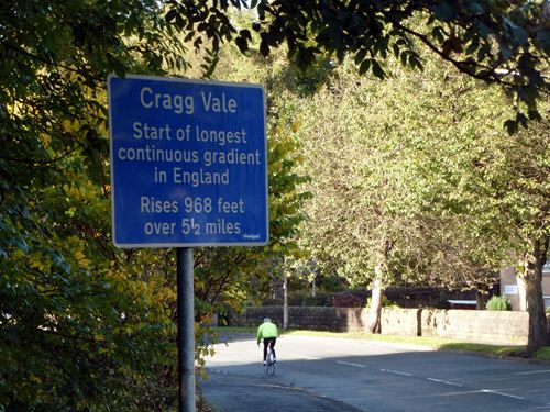 The Pennine moors south of the Calder Valley are high and rolling, in places almost inaccessibly steep. The B6138 which climbs south up Cragg Vale out of Mytholmroyd, east of Hebden Bridge, is an exception and offers a wonderful long and well-graded climb up onto the wilds of the moors on Blackstone Edge. The first few kilometres climb through wooded villages before the road finally emerges out onto open moorland. On a warm summer day this is hospitably good climbing, in the bleak midwinter it is exposed and not quite so friendly. Invariably it will be ridden into a stiff headwind, making it all the more demanding. The last 4 kilometers keep climbing relentlessly until the summit is finally reached at Blackstone Edge Reservoir. Listed as the longest continuous road climb in England, it is good Alpine climbing practice.
Total ascent: 295m
Distance: 8.8km
Average Gradient: 3.4%
Best time: 26' 46
Cheddar Gorge, Somerset
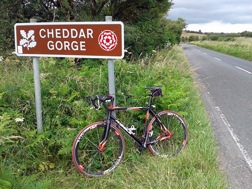 Cheddar Gorge is one of those iconic climbs which conjours up images in the mind of twisting tarmac surrounded by spectacular cliff scenery. It does not disappoint. The tourist village of Cheddar at the foot of the climb is a distraction and demands attention as you negotiate the hundreds of visitors busying themselves, many of them in the road. The climb, for my money, starts at the little bridge at the foot of the main street, though there is an argument for starting higher up, above the busy main drag. Either way, once past the last of the tat shops and the cave entrances you can relax into some kind of rhythm and start to enjoy the climb as it unfolds. Nowhere do you get a long view ahead, and this is part of the delight. First one corner, then another, the road winds its way up through the most amazing rock scenery which towers hundreds of feet above your head. And then the road kicks up and suddenly the gradient is pushing 20% into a tightening bend, your legs feeling the strain. After that the gradient eases again and the rest of the climb gradually eases as your speed increases. The cliff scenery gives way to trees and, finally, after nearly 5 kilometers, the road emerges into farmland high on the Mendip ridge, finishing at a farm entrance. A climb to savour, so good you'll want to go down and ride it again. I did!
Total ascent: 188m
Distance: 4.7km
Average Gradient: 4.0%
Best time: 15' 13sec
Haytor, Devon
 The Tour of Britain has been a frequent visitor to Devon and Dartmoor over the years, and in 2013 this climb featured as a summit finish on stage 6. Starting in the market town of Bovey Tracey the climb is a steady and persistent drag for some 6 kilometers up through woodland and out onto the open moor, finishing just below the distinctive outcrop of Haytor Rocks. The first kilometer is very much a warmup before the real work begins as the gradient steepens to 10%. From here there is no real let-up until you reach the moors, with occasional ramps of 15%. The views to the south are glorious and help to distract the weary rider, if required. There is a brief respite as you pass the Haytor Visitor Centre before the final 500m ramp to the summit and relief. Rest awhile and soak up the extensive views to the Devon coast. If you're really up for it there is often an ice-cream van parked up in the car park at the summit (it's hard not to be tempted!) I don't suppose the pros will be indulging though
Total ascent: 367m
Distance: 5.99km
Average Gradient: 6.1%
Best time: 25' 47sec
Nick O'Pendle, Lancashire
 Used on the Tour of Britain in previous years this is a great little climb south of Clitheroe, taking the road over the Nick O'Pendlebefore plummeting down to Sabden. Having crossed the A59 the climb begins immediately up the minor road onto Pendleton Moor. Gradually it ramps up with a couple of steeper sections as it crosses a cattle grid onto open moor. Here it hits a short 25% section which saps the tiring legs before a final push to the "nick" and a sprint round the final bend. The climb features in the Pendle Pedal sportive, and is a real tester coming late in the day. And one final noteworthy point, both Malcolm Elliot and Chris Boardman have won the National Hillclimb champs here in 1980 and 1988 respectively.
Total ascent: 185m
Distance: 3km
Average Gradient: 6.2%
Best time: 11' 25sec
Bollihope Common, Stanhope, Weardale
 This is a climb of two halves and rivals some European climbs in its length and difficulty. Taking the B6278 south out of Stanhope it is easy to be lulled into a false sense of security as the road meanders alongside the river for a kilometre or so. Then the road takes a sharp right turn and heads into the sky. Brutal? Just a touch. This is Unthank Bank. The next 500m is a real wakeup call with hairpins and real out-of-the-saddle effort before it eases and you can settle into a bit of rhythm. Now the real climb begins as the road heads up onto Catterick Moss and open moorland. Real Pennine country, wild with it. Having reached the 400m contour after some 4.2km of climbing the road now plummets down to the Bollihope Burn and then rises once again on to Bollihope Common itself. This last part of the climb is almost Alpine in its nature and saps the legs before you finally top out at 511m and can take in the awesome wild views.
Total ascent: 450m
Distance: 9.5km
Average Gradient: 4.7%
Best time: Approx 35'
Buttertubs Pass, Swaledale
 Another Yorkshire climb, this is another classic and has featured in a number of national events including the Etape du Dales. The climb south from Thwaite in Swaledale is, in my view, the harder and makes heavy demands on the legs with two steep 25% sections. The start is innocent enough, as the road drags up out of Thwaite village at a steady gradient before rounding a sharp right and then ramping up. This is hard. Having struggled up this section you could be forgiven for thinking the worst is over but another steady section with even a cheeky bit of downhill only softens you up before the final haul to the summit of the pass and collapse! The views back down into Swaledale make it all worthwhile (well, almost). As an alternative, try doing the climb from Hawes to the south. Longer and not quite so steep, but still challenging enough.
(from Thwaite)
Total ascent: 260m
Distance: 4km
Average Gradient: 6.5%
Best time: Approx 15'
(from Hawes)
Total ascent: 275m
Distance: 5km
Average Gradient: 5.5%
Best time: 19'53"
Bwlch Penbarras, Ruthin
 This can only be described as a brute of a climb. Short but not sweet, the climb starts at a minor road turn off the main A494 road to Mold and climbs through trees before opening out over a cattle grid. At this point a tough climb becomes brutal as the roads steepens to close to 30% and the legs scream. This continues for 250m before a left hairpin where the gradient is unrideable on the apex of the bend, the only option is to take it wide. After this it eases to a "gentle" 10% or so before the road swings back round the hillside and the summit comes into view. Now the sting in the tail as it pitches up again, never as steep as before, but enough to have you asking why, oh why you came this way! Then, finally, you crawl over the summit and collapse to recover. Great climb!!
Total ascent: 249m
Distance: 2.3km
Average Gradient: 10.9%
Best time: 14'56"
Moel Arthur, Ruthin
As with Bwlch Penbarrra, this is another real brute. The Clwyd hills present a very steep approach from the west, there really is no easy way over them. Moel Arthur is no exception. Different in character, rougher and less well frequented than Penbarras, it offers a real challenge, especially to tired legs! It starts from the crossroads at Groes-Fawr, on a minor road north of Ruthin and the climb begins in earnest straightaway. Then it gets worse. Two sections of 25% test the willpower, before it eases and the slopes of Moel Arthue (the hill) hove into view. The last 600m or so are decidedly easier but the legs by now have little left to offer. The cattle grid at the summit is a welcome sight indeed. The views are good though!!Total ascent: 218m
Distance: 2.3km
Average Gradient: 9.5%
Best time: 15' 05"